April Showers & Chilly Nights: Your Comprehensive NYC Weather Guide
By
Amy Freeze
Meteorologist Amy Freeze provides an in-depth look at this week's weather in NYC and the Northeast. From evening showers to cooler temperatures, find out what to expect!
From scattered showers to lower temperatures, Meteorologist Amy Freeze maps out the forecast for NYC this week.
April in New York City brings not just showers but a finely detailed forecast by Meteorologist Amy Freeze. Light showers usher in the evening with clear trends toward cooler nights throughout the Northeast, with some areas seeing temperatures dipping below seasonal averages. A complex system promises varying weather across the region – from heavy rain threatening evening commutes in New York City and Albany to clear skies in Portland. Plan effectively with our insider knowledge as the week unfolds!
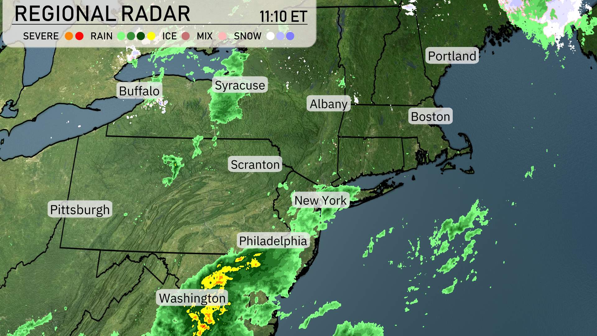
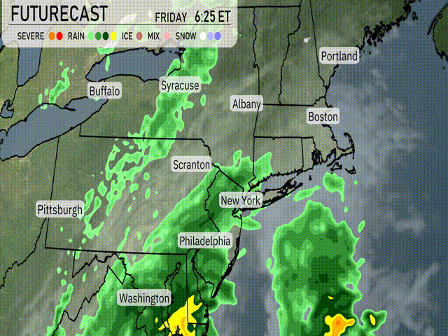
Over the Northeast, the radar shows a dynamic weather setup. Heavy rain is sweeping through Washington D.C. and moving up towards Philadelphia, bringing a wet and windy day ahead. Clouds are thickening as you move north, with New York City beginning to see spotty showers.
Syracuse and areas around Buffalo are experiencing light rain, while farther east, Albany and Boston have overcast skies but remain dry for now. Snow has made an appearance in the far north near the Canadian border, indicating colder conditions there.
Portland is enjoying clearer skies, though clouds are visible on the horizon, hinting at potential weather changes later today. Scranton finds itself on the edge of this rainy system, seeing only light sprinkles at this time.
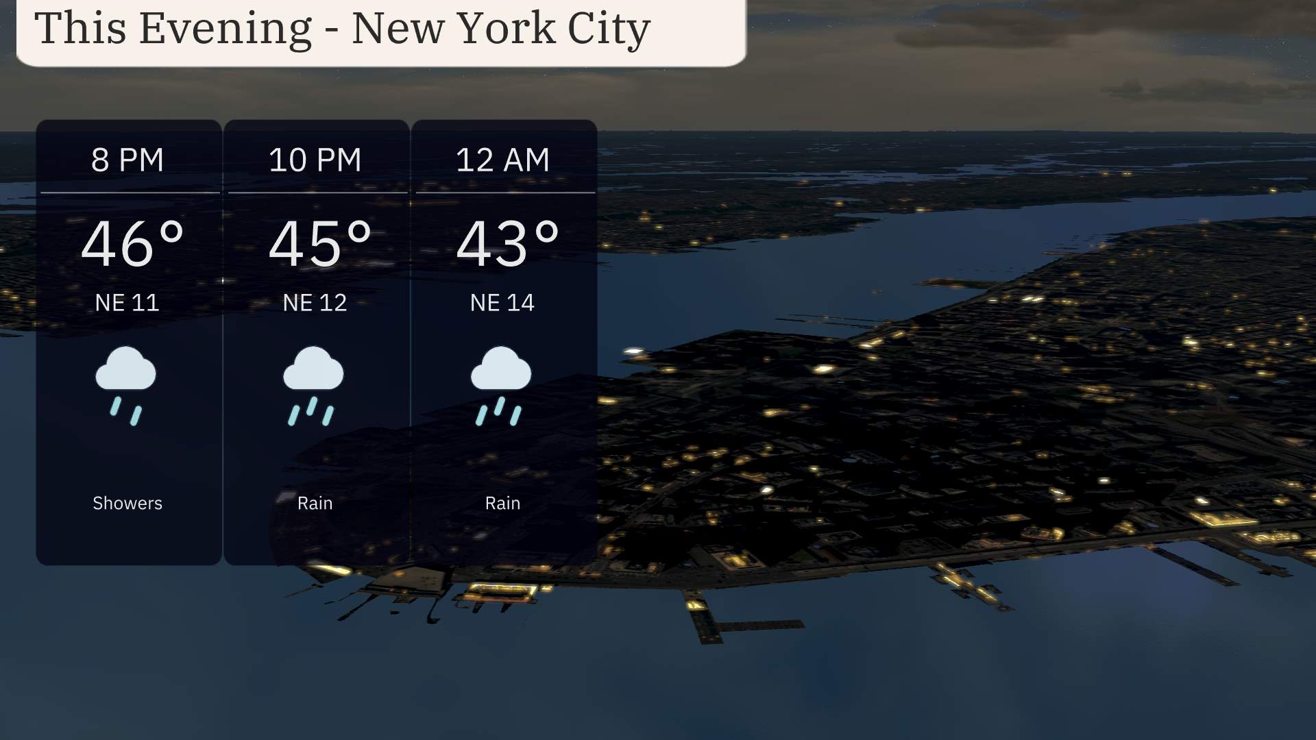
This evening in New York City, expect a bit of a wet outlook as light showers begin around 8 PM with temperatures starting at 46 degrees. As the evening progresses, temperatures will dip slightly to 45 degrees by 10 PM, accompanied by a northeast breeze at 12 mph. More persistent rain is on the horizon around midnight, with temperatures reaching 43 degrees and winds strengthening to 14 mph.
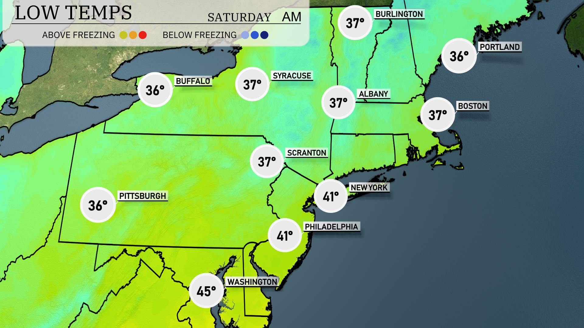
Tonight in the Northeast, we’ll see notably cooler temperatures settling in. Expect a chilly low of 36 degrees in Buffalo and 37 in Syracuse. Pittsburgh will also see a low of 36. Scranton and New York City are forecasted for 37 degrees. Philadelphia is looking at a slightly warmer low of 41, while Boston and Portland will dip to 36 degrees.
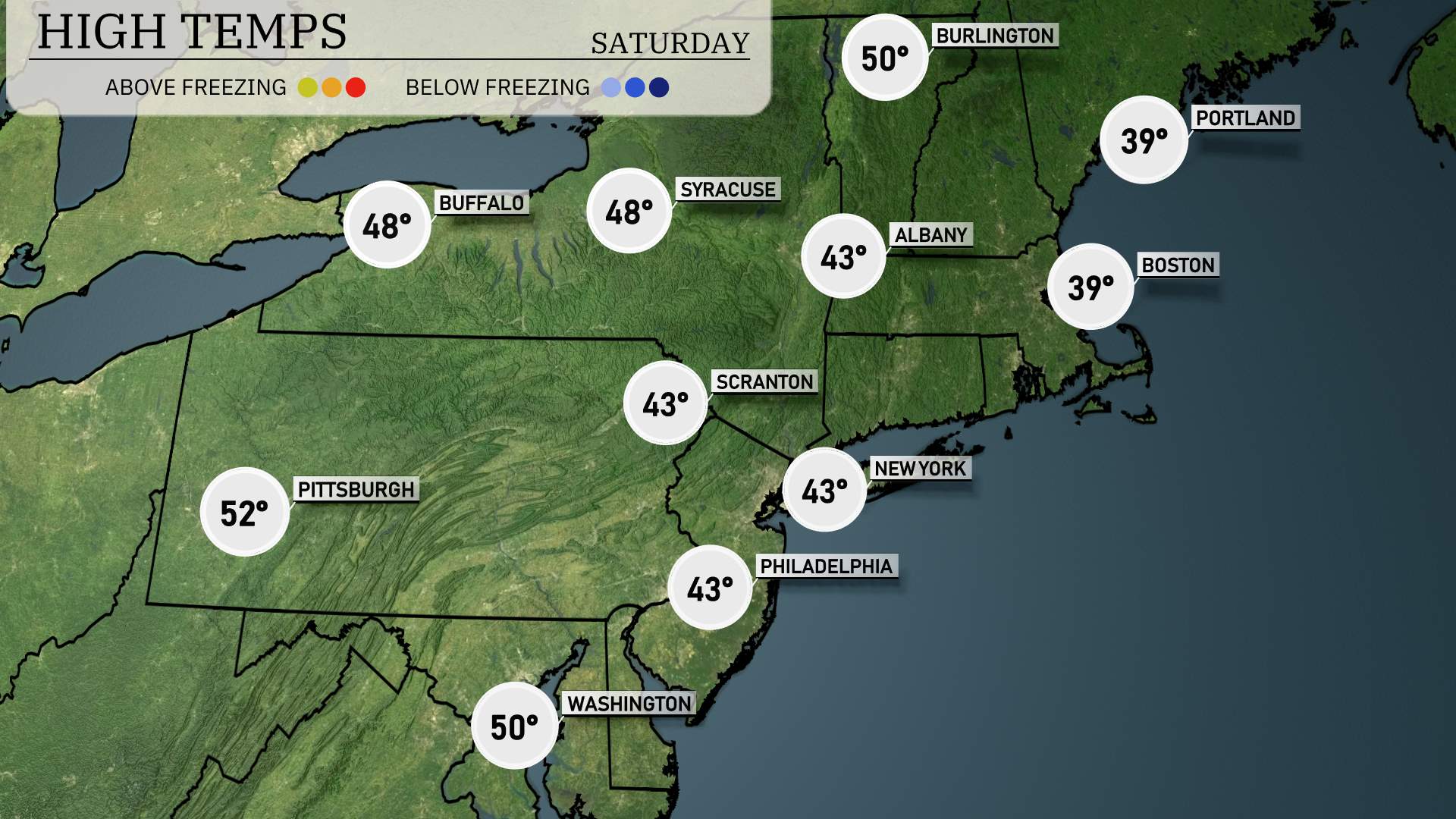
High temperatures in the Northeast for tomorrow are generally on the cooler side, remaining below seasonal averages due to an influx of cold air.
In Boston, expect a high only reaching 39 degrees. New York City is similar, with temperatures peaking at 43. Philadelphia, Scranton, and Albany all hover around 43 degrees as well. Pittsburgh shows a slight warm-up compared to its neighbors, with a high of 52 degrees, while Buffalo and Syracuse struggle to reach 48.
The weather pattern driving these cool temperatures is a lingering cold front that continues to influence the region, keeping conditions chilly and stable.
Expectation for the Northeast tomorrow shows a cold front moving across the region with rain showers impacting areas from Washington, D.C. to Portland. Albany and New York City should prepare for possible heavy rain later in the day, which could disrupt evening commutes. Severe storms are less likely, but rapid rainfall may lead to localized flooding, particularly in urban areas. As the system progresses, temperatures are set to drop behind the front, bringing more mild but dry conditions by Saturday. Keep vigilant for travel disruptions and adjust plans accordingly.
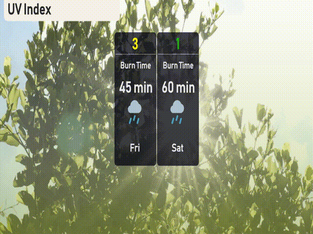
In New York City, the UV index will be low for both Friday and Saturday due to cloud cover and rain, significantly diminishing sun exposure risks.
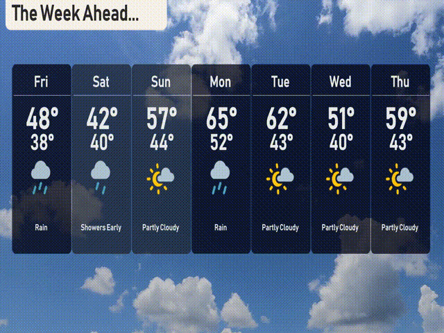
For the 7-day outlook in New York City:
Friday: Expect rain with a high of 48 degrees and a low of 38.
Saturday: Showers early, then clearing with a high of 42 degrees and a low of 40.
Sunday: Partly cloudy skies, warmer with a high of 57 degrees, cooling to 44 at night.
Monday: More rain is on the way, with temperatures reaching a high of 65 degrees, and a low of 52.
Tuesday: The sun peeks through with a mix of sun and clouds, temperatures at 62 degrees during the day, and 43 at night.
Wednesday: A cooling trend as temperatures dip to a high of 51 degrees with partly cloudy skies, and a low of 40.
Thursday: Partly cloudy conditions continue with a high of 59 degrees, and an evening low of 43.
Enjoy the week ahead!